


Springhill Voting Booth, Marengo County, Alabama
About
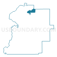
Outline

Summary
| Unique Area Identifier | 522424 |
| Name | Springhill Voting Booth |
| County | Marengo County |
| State | Alabama |
| Area (square miles) | 12.45 |
| Land Area (square miles) | 12.44 |
| Water Area (square miles) | 0.01 |
| % of Land Area | 99.94 |
| % of Water Area | 0.06 |
| Latitude of the Internal Point | 32.45714080 |
| Longtitude of the Internal Point | -87.75044010 |
Maps


Graphs
Select a template below for downloading or customizing gragh for Springhill Voting Booth, Marengo County, Alabama


Neighbors
Neighoring Voting District (by Name) Neighboring Voting District on the Map
- Demopolis High School, Marengo County, AL
- Faunsdale, Marengo County, AL
- Gallion, Hale County, AL
- National Guard Armory, Marengo County, AL
- Rangeline, Marengo County, AL
- VFW, Marengo County, AL
Top 10 Neighboring County Subdivision (by Population) Neighboring County Subdivision on the Map
- Demopolis CCD, Marengo County, AL (9,554)
- Linden CCD, Marengo County, AL (4,762)
- Newbern CCD, Hale County, AL (1,562)
- Faunsdale CCD, Marengo County, AL (782)
Top 10 Neighboring Unified School District (by Population) Neighboring Unified School District on the Map
- Hale County School District, AL (15,760)
- Marengo County School District, AL (8,822)
- Linden City School District, AL (4,722)
Top 10 Neighboring State Legislative District Lower Chamber (by Population) Neighboring State Legislative District Lower Chamber on the Map
Top 10 Neighboring State Legislative District Upper Chamber (by Population) Neighboring State Legislative District Upper Chamber on the Map
Top 10 Neighboring 111th Congressional District (by Population) Neighboring 111th Congressional District on the Map
Top 10 Neighboring Census Tract (by Population) Neighboring Census Tract on the Map
- Census Tract 9729, Marengo County, AL (5,235)
- Census Tract 9730, Marengo County, AL (4,762)
- Census Tract 9731, Marengo County, AL (2,150)
- Census Tract 405, Hale County, AL (1,562)